Species Report
Wood Thrush
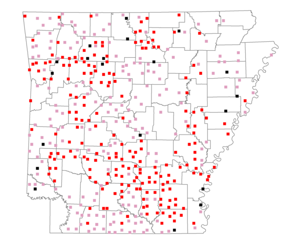
Total number of 2,500 hectare plots where this species is found: 406 ( 46.4% of plots )
| CATEGORY | Hectares, 1994 | % of Total, 1994 | Hectares, 1999 | % of Total, 1999 | Hectares, 2004 | % of Total, 2004 |
| Forest - Total (All Categories) | 757114.2 | 67.31 | 754192.0 | 74.28 | 742566.6 | 73.14 |
| Ozark-Ouachita Pine-Oak Forest | 217097.5 | 19.30 | 192186.7 | 18.93 | 189401.2 | 18.66 |
| Ozark-Ouachita Dry Oak Woodland and Forest | 24891.2 | 2.21 | 19354.5 | 1.91 | 19197.8 | 1.89 |
| Central Interior Highlands Glade and Barrens | 26814.9 | 2.38 | 22329.1 | 2.20 | 22170.7 | 2.18 |
| Mesic Hardwood Forest | 1694.1 | 0.15 | 1491.4 | 0.15 | 1483.6 | 0.15 |
| Dry-Mesic Oak Forest | 163199.4 | 14.51 | 140370.8 | 13.83 | 138204.4 | 13.61 |
| West Gulf Coastal Plain Pine-Hardwood Forest | 171323.8 | 15.23 | 149032.9 | 14.68 | 138512.7 | 13.64 |
| West Gulf Coastal Plain Small Stream Forest | 529.1 | 0.05 | 394.4 | 0.04 | 403.5 | 0.04 |
| Lower Mississippi River Low Bottomland Forest | 31282.4 | 2.78 | 25511.2 | 2.51 | 24985.0 | 2.46 |
| Lower Mississippi River High Bottomland Forest | 111078.8 | 9.88 | 95215.4 | 9.38 | 93361.2 | 9.20 |
| Lower Mississippi River Bottomland Depression | 5789.0 | 0.51 | 4917.0 | 0.48 | 4704.1 | 0.46 |
| Lower Mississippi River Riparian Forest | 660.8 | 0.06 | 412.4 | 0.04 | 440.7 | 0.04 |
| Sweetgum | 2753.2 | 0.24 | 2312.6 | 0.23 | 2248.6 | 0.22 |
| Forest - Unknown Category | 0.0 | 0.00 | 100663.7 | 9.91 | 107453.0 | 10.58 |
| Cropland | 114175.4 | 10.15 | 79518.1 | 7.83 | 75936.4 | 7.48 |
| Pastureland | 198391.3 | 17.64 | 123479.2 | 12.16 | 119051.6 | 11.73 |
| Herbaceous | 1854.4 | 0.16 | 11487.6 | 1.13 | 19004.9 | 1.87 |
| Bare/Barren | 633.8 | 0.06 | 599.8 | 0.06 | 865.9 | 0.09 |
| Urban | 3400.3 | 0.30 | 6288.5 | 0.62 | 19436.9 | 1.91 |
| Water | 36429.9 | 3.24 | 28387.2 | 2.80 | 27070.3 | 2.67 |
| Unknown (No Data) | 12741.3 | 1.13 | 11330.6 | 1.12 | 11350.3 | 1.12 |