Species Report
Wood Stork
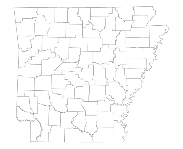
Total number of 2,500 hectare plots where this species is found: 2 ( 0.2% of plots )
| CATEGORY | Hectares, 1994 | % of Total, 1994 | Hectares, 1999 | % of Total, 1999 | Hectares, 2004 | % of Total, 2004 |
| Forest - Total (All Categories) | 4687.5 | 84.79 | 4533.0 | 90.86 | 4474.7 | 89.69 |
| Ozark-Ouachita Pine-Oak Forest | 0.0 | 0.00 | 0.0 | 0.00 | 0.0 | 0.00 |
| Ozark-Ouachita Dry Oak Woodland and Forest | 0.0 | 0.00 | 0.0 | 0.00 | 0.0 | 0.00 |
| Central Interior Highlands Glade and Barrens | 0.0 | 0.00 | 0.0 | 0.00 | 0.0 | 0.00 |
| Mesic Hardwood Forest | 0.0 | 0.00 | 0.0 | 0.00 | 0.0 | 0.00 |
| Dry-Mesic Oak Forest | 339.8 | 6.15 | 306.9 | 6.15 | 305.9 | 6.13 |
| West Gulf Coastal Plain Pine-Hardwood Forest | 377.0 | 6.82 | 320.0 | 6.41 | 299.4 | 6.00 |
| West Gulf Coastal Plain Small Stream Forest | 0.0 | 0.00 | 0.0 | 0.00 | 0.0 | 0.00 |
| Lower Mississippi River Low Bottomland Forest | 148.1 | 2.68 | 130.4 | 2.61 | 126.3 | 2.53 |
| Lower Mississippi River High Bottomland Forest | 2487.3 | 44.99 | 2179.0 | 43.67 | 2178.0 | 43.65 |
| Lower Mississippi River Bottomland Depression | 1335.4 | 24.16 | 1137.4 | 22.80 | 1140.9 | 22.87 |
| Lower Mississippi River Riparian Forest | 0.0 | 0.00 | 0.0 | 0.00 | 0.0 | 0.00 |
| Sweetgum | 0.0 | 0.00 | 0.0 | 0.00 | 0.0 | 0.00 |
| Forest - Unknown Category | 0.0 | 0.00 | 459.2 | 9.20 | 424.2 | 8.50 |
| Cropland | 0.0 | 0.00 | 0.0 | 0.00 | 0.0 | 0.00 |
| Pastureland | 137.8 | 2.49 | 0.0 | 0.00 | 7.4 | 0.15 |
| Herbaceous | 0.0 | 0.00 | 46.2 | 0.93 | 62.2 | 1.25 |
| Bare/Barren | 0.0 | 0.00 | 0.0 | 0.00 | 0.0 | 0.00 |
| Urban | 0.0 | 0.00 | 0.0 | 0.00 | 30.7 | 0.62 |
| Water | 699.8 | 12.66 | 410.0 | 8.22 | 414.2 | 8.30 |
| Unknown (No Data) | 3.1 | 0.06 | 0.0 | 0.00 | 0.0 | 0.00 |