Species Report
Whip-poor-will
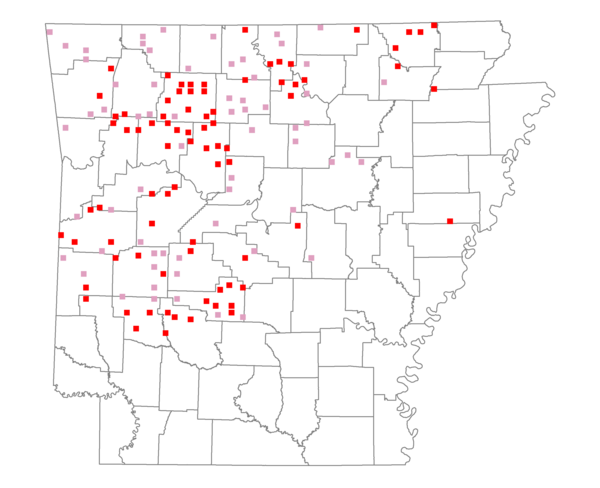
Total number of 2,500 hectare plots where this species is found: 145 ( 16.6% of plots )
| CATEGORY | Hectares, 1994 | % of Total, 1994 | Hectares, 1999 | % of Total, 1999 | Hectares, 2004 | % of Total, 2004 |
| Forest - Total (All Categories) | 289885.8 | 72.15 | 290137.3 | 80.01 | 288846.9 | 79.66 |
| Ozark-Ouachita Pine-Oak Forest | 146002.4 | 36.34 | 129595.5 | 35.74 | 128264.4 | 35.37 |
| Ozark-Ouachita Dry Oak Woodland and Forest | 15792.2 | 3.93 | 12277.3 | 3.39 | 12131.2 | 3.35 |
| Central Interior Highlands Glade and Barrens | 20797.8 | 5.18 | 17019.7 | 4.69 | 16985.3 | 4.68 |
| Mesic Hardwood Forest | 1616.1 | 0.40 | 1418.5 | 0.39 | 1408.8 | 0.39 |
| Dry-Mesic Oak Forest | 90300.5 | 22.48 | 77897.5 | 21.48 | 77037.0 | 21.25 |
| West Gulf Coastal Plain Pine-Hardwood Forest | 6840.2 | 1.70 | 6110.9 | 1.69 | 5720.4 | 1.58 |
| West Gulf Coastal Plain Small Stream Forest | 3.9 | 0.00 | 3.3 | 0.00 | 3.3 | 0.00 |
| Lower Mississippi River Low Bottomland Forest | 527.5 | 0.13 | 393.2 | 0.11 | 427.4 | 0.12 |
| Lower Mississippi River High Bottomland Forest | 7028.7 | 1.75 | 6013.0 | 1.66 | 5921.2 | 1.63 |
| Lower Mississippi River Bottomland Depression | 0.0 | 0.00 | 0.0 | 0.00 | 0.0 | 0.00 |
| Lower Mississippi River Riparian Forest | 132.8 | 0.03 | 104.9 | 0.03 | 108.1 | 0.03 |
| Sweetgum | 843.8 | 0.21 | 705.3 | 0.19 | 689.0 | 0.19 |
| Forest - Unknown Category | 0.0 | 0.00 | 38598.0 | 10.64 | 40150.8 | 11.07 |
| Cropland | 12454.7 | 3.10 | 6230.0 | 1.72 | 6805.0 | 1.88 |
| Pastureland | 92722.6 | 23.08 | 59930.2 | 16.53 | 56629.5 | 15.62 |
| Herbaceous | 6.1 | 0.00 | 354.6 | 0.10 | 992.4 | 0.27 |
| Bare/Barren | 26.6 | 0.01 | 43.5 | 0.01 | 182.8 | 0.05 |
| Urban | 672.7 | 0.17 | 1250.1 | 0.34 | 4760.5 | 1.31 |
| Water | 5431.1 | 1.35 | 4187.3 | 1.15 | 3904.6 | 1.08 |
| Unknown (No Data) | 557.5 | 0.14 | 478.6 | 0.13 | 489.6 | 0.14 |