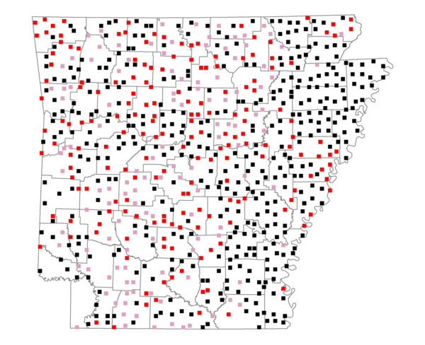
Species Report
Red-winged Blackbird

Total number of 2,500 hectare plots where this species is found: 706 ( 80.7% of plots )
| CATEGORY | Hectares, 1994 | % of Total, 1994 | Hectares, 1999 | % of Total, 1999 | Hectares, 2004 | % of Total, 2004 |
| Forest - Total (All Categories) | 964546.0 | 49.31 | 970111.7 | 54.95 | 964014.3 | 54.61 |
| Ozark-Ouachita Pine-Oak Forest | 258090.0 | 13.19 | 224717.6 | 12.73 | 220650.1 | 12.50 |
| Ozark-Ouachita Dry Oak Woodland and Forest | 45018.3 | 2.30 | 33849.8 | 1.92 | 33231.4 | 1.88 |
| Central Interior Highlands Glade and Barrens | 39850.2 | 2.04 | 31848.7 | 1.80 | 31539.2 | 1.79 |
| Mesic Hardwood Forest | 2233.1 | 0.11 | 1950.5 | 0.11 | 1945.2 | 0.11 |
| Dry-Mesic Oak Forest | 241770.3 | 12.36 | 197168.3 | 11.17 | 192457.4 | 10.90 |
| West Gulf Coastal Plain Pine-Hardwood Forest | 158838.9 | 8.12 | 137645.0 | 7.80 | 129450.7 | 7.33 |
| West Gulf Coastal Plain Small Stream Forest | 1432.8 | 0.07 | 754.6 | 0.04 | 754.7 | 0.04 |
| Lower Mississippi River Low Bottomland Forest | 52995.6 | 2.71 | 39582.4 | 2.24 | 39661.8 | 2.25 |
| Lower Mississippi River High Bottomland Forest | 148976.4 | 7.62 | 123567.7 | 7.00 | 121319.9 | 6.87 |
| Lower Mississippi River Bottomland Depression | 7022.7 | 0.36 | 5683.1 | 0.32 | 5566.1 | 0.32 |
| Lower Mississippi River Riparian Forest | 1825.5 | 0.09 | 574.7 | 0.03 | 663.3 | 0.04 |
| Sweetgum | 6492.2 | 0.33 | 5243.6 | 0.30 | 5055.8 | 0.29 |
| Forest - Unknown Category | 0.0 | 0.00 | 167525.7 | 9.49 | 181718.9 | 10.29 |
| Cropland | 512409.8 | 26.20 | 398407.9 | 22.57 | 390969.2 | 22.15 |
| Pastureland | 384323.3 | 19.65 | 296924.2 | 16.82 | 278992.6 | 15.80 |
| Herbaceous | 4203.9 | 0.21 | 15874.2 | 0.90 | 23512.9 | 1.33 |
| Bare/Barren | 2162.4 | 0.11 | 948.5 | 0.05 | 2036.9 | 0.12 |
| Urban | 8918.6 | 0.46 | 15733.8 | 0.89 | 42491.9 | 2.41 |
| Water | 55183.2 | 2.82 | 45739.5 | 2.59 | 41681.3 | 2.36 |
| Unknown (No Data) | 24308.6 | 1.24 | 21612.1 | 1.22 | 21653.0 | 1.23 |