Species Report
Red-tailed Hawk
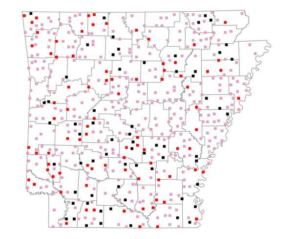
Total number of 2,500 hectare plots where this species is found: 511 ( 58.4% of plots )
| CATEGORY | Hectares, 1994 | % of Total, 1994 | Hectares, 1999 | % of Total, 1999 | Hectares, 2004 | % of Total, 2004 |
| Forest - Total (All Categories) | 762307.5 | 53.85 | 769376.3 | 60.21 | 762869.9 | 59.70 |
| Ozark-Ouachita Pine-Oak Forest | 214780.8 | 15.17 | 188098.1 | 14.72 | 184757.6 | 14.46 |
| Ozark-Ouachita Dry Oak Woodland and Forest | 30389.4 | 2.15 | 23148.2 | 1.81 | 22824.6 | 1.79 |
| Central Interior Highlands Glade and Barrens | 25420.5 | 1.80 | 19959.3 | 1.56 | 19874.2 | 1.56 |
| Mesic Hardwood Forest | 1367.2 | 0.10 | 1194.1 | 0.09 | 1193.6 | 0.09 |
| Dry-Mesic Oak Forest | 180674.8 | 12.76 | 148007.4 | 11.58 | 144591.9 | 11.32 |
| West Gulf Coastal Plain Pine-Hardwood Forest | 142628.6 | 10.07 | 123333.7 | 9.65 | 115713.5 | 9.06 |
| West Gulf Coastal Plain Small Stream Forest | 757.1 | 0.05 | 485.7 | 0.04 | 449.4 | 0.04 |
| Lower Mississippi River Low Bottomland Forest | 41527.4 | 2.93 | 31646.9 | 2.48 | 31757.7 | 2.49 |
| Lower Mississippi River High Bottomland Forest | 115099.7 | 8.13 | 96532.0 | 7.55 | 94740.0 | 7.41 |
| Lower Mississippi River Bottomland Depression | 4554.3 | 0.32 | 3722.3 | 0.29 | 3622.8 | 0.28 |
| Lower Mississippi River Riparian Forest | 933.4 | 0.07 | 361.7 | 0.03 | 422.0 | 0.03 |
| Sweetgum | 4174.3 | 0.29 | 3451.3 | 0.27 | 3380.0 | 0.26 |
| Forest - Unknown Category | 0.0 | 0.00 | 129435.5 | 10.13 | 139542.6 | 10.92 |
| Cropland | 308413.8 | 21.78 | 234950.5 | 18.39 | 229493.4 | 17.96 |
| Pastureland | 280552.7 | 19.82 | 204231.4 | 15.98 | 194655.3 | 15.23 |
| Herbaceous | 3181.5 | 0.22 | 13651.7 | 1.07 | 19366.1 | 1.52 |
| Bare/Barren | 1021.2 | 0.07 | 672.2 | 0.05 | 1360.1 | 0.11 |
| Urban | 5145.2 | 0.36 | 10047.0 | 0.79 | 27717.2 | 2.17 |
| Water | 37873.7 | 2.68 | 29583.2 | 2.32 | 26978.9 | 2.11 |
| Unknown (No Data) | 17231.7 | 1.22 | 15340.7 | 1.20 | 15412.1 | 1.21 |