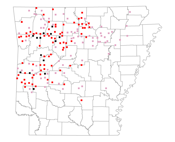
Species Report
Ovenbird

Total number of 2,500 hectare plots where this species is found: 171 ( 19.5% of plots )
| CATEGORY | Hectares, 1994 | % of Total, 1994 | Hectares, 1999 | % of Total, 1999 | Hectares, 2004 | % of Total, 2004 |
| Forest - Total (All Categories) | 353149.2 | 74.54 | 348784.6 | 81.58 | 346565.0 | 81.07 |
| Ozark-Ouachita Pine-Oak Forest | 195989.6 | 41.37 | 173959.7 | 40.69 | 171979.5 | 40.23 |
| Ozark-Ouachita Dry Oak Woodland and Forest | 16976.7 | 3.58 | 13556.3 | 3.17 | 13427.6 | 3.14 |
| Central Interior Highlands Glade and Barrens | 20357.6 | 4.30 | 17128.9 | 4.01 | 16967.3 | 3.97 |
| Mesic Hardwood Forest | 2322.6 | 0.49 | 2039.9 | 0.48 | 2032.7 | 0.48 |
| Dry-Mesic Oak Forest | 102390.8 | 21.61 | 88817.3 | 20.78 | 88125.8 | 20.61 |
| West Gulf Coastal Plain Pine-Hardwood Forest | 3727.6 | 0.79 | 3264.4 | 0.76 | 2804.7 | 0.66 |
| West Gulf Coastal Plain Small Stream Forest | 177.6 | 0.04 | 152.9 | 0.04 | 150.4 | 0.04 |
| Lower Mississippi River Low Bottomland Forest | 1523.9 | 0.32 | 1164.3 | 0.27 | 1150.1 | 0.27 |
| Lower Mississippi River High Bottomland Forest | 8017.6 | 1.69 | 6774.0 | 1.58 | 6669.7 | 1.56 |
| Lower Mississippi River Bottomland Depression | 7.0 | 0.00 | 2.9 | 0.00 | 6.3 | 0.00 |
| Lower Mississippi River Riparian Forest | 194.0 | 0.04 | 156.4 | 0.04 | 162.9 | 0.04 |
| Sweetgum | 1464.2 | 0.31 | 1248.7 | 0.29 | 1197.4 | 0.28 |
| Forest - Unknown Category | 0.0 | 0.00 | 40519.0 | 9.48 | 41890.6 | 9.80 |
| Cropland | 22915.1 | 4.84 | 13921.4 | 3.26 | 14287.6 | 3.34 |
| Pastureland | 89023.5 | 18.79 | 57253.0 | 13.39 | 55215.2 | 12.92 |
| Herbaceous | 106.1 | 0.02 | 443.0 | 0.10 | 1254.0 | 0.29 |
| Bare/Barren | 107.4 | 0.02 | 7.3 | 0.00 | 135.2 | 0.03 |
| Urban | 582.5 | 0.12 | 957.2 | 0.22 | 4372.3 | 1.02 |
| Water | 6443.8 | 1.36 | 4881.9 | 1.14 | 4419.3 | 1.03 |
| Unknown (No Data) | 1424.4 | 0.30 | 1265.9 | 0.30 | 1265.7 | 0.30 |