Species Report
Northern Parula
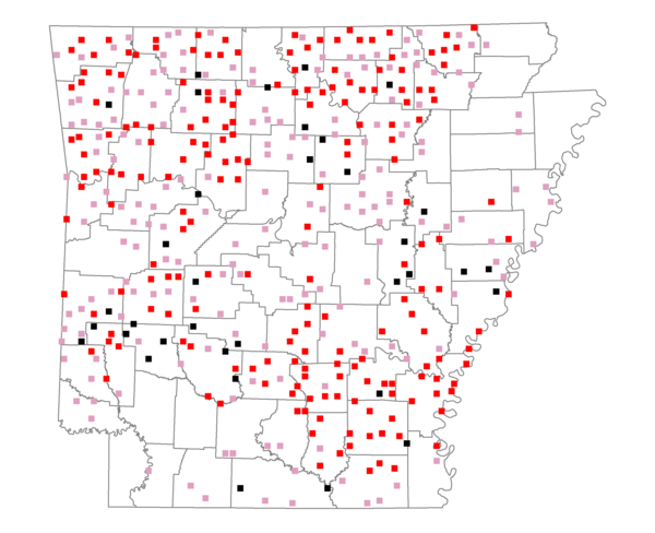
Total number of 2,500 hectare plots where this species is found: 417 ( 47.7% of plots )
| CATEGORY | Hectares, 1994 | % of Total, 1994 | Hectares, 1999 | % of Total, 1999 | Hectares, 2004 | % of Total, 2004 |
| Forest - Total (All Categories) | 707274.4 | 61.21 | 710860.1 | 68.17 | 701625.7 | 67.28 |
| Ozark-Ouachita Pine-Oak Forest | 212567.8 | 18.40 | 187364.3 | 17.97 | 184690.1 | 17.71 |
| Ozark-Ouachita Dry Oak Woodland and Forest | 45923.6 | 3.97 | 35418.2 | 3.40 | 34782.9 | 3.34 |
| Central Interior Highlands Glade and Barrens | 37331.1 | 3.23 | 30358.4 | 2.91 | 30024.9 | 2.88 |
| Mesic Hardwood Forest | 1887.9 | 0.16 | 1661.0 | 0.16 | 1655.0 | 0.16 |
| Dry-Mesic Oak Forest | 185196.4 | 16.03 | 156160.4 | 14.98 | 152990.3 | 14.67 |
| West Gulf Coastal Plain Pine-Hardwood Forest | 88950.5 | 7.70 | 77517.0 | 7.43 | 71803.6 | 6.89 |
| West Gulf Coastal Plain Small Stream Forest | 879.1 | 0.08 | 561.9 | 0.05 | 598.0 | 0.06 |
| Lower Mississippi River Low Bottomland Forest | 29494.7 | 2.55 | 23619.1 | 2.26 | 23380.1 | 2.24 |
| Lower Mississippi River High Bottomland Forest | 96882.4 | 8.38 | 82477.1 | 7.91 | 80772.1 | 7.75 |
| Lower Mississippi River Bottomland Depression | 4469.9 | 0.39 | 3695.7 | 0.35 | 3594.5 | 0.34 |
| Lower Mississippi River Riparian Forest | 745.5 | 0.06 | 413.2 | 0.04 | 454.9 | 0.04 |
| Sweetgum | 2945.5 | 0.25 | 2501.0 | 0.24 | 2443.2 | 0.23 |
| Forest - Unknown Category | 0.0 | 0.00 | 109112.7 | 10.46 | 114436.1 | 10.97 |
| Cropland | 140337.1 | 12.15 | 95209.0 | 9.13 | 92450.5 | 8.87 |
| Pastureland | 249262.4 | 21.57 | 180042.0 | 17.27 | 173589.4 | 16.65 |
| Herbaceous | 961.3 | 0.08 | 8473.2 | 0.81 | 13102.8 | 1.26 |
| Bare/Barren | 927.7 | 0.08 | 790.6 | 0.08 | 1143.6 | 0.11 |
| Urban | 4757.8 | 0.41 | 6260.3 | 0.60 | 20650.8 | 1.98 |
| Water | 35690.6 | 3.09 | 26664.5 | 2.56 | 25693.5 | 2.46 |
| Unknown (No Data) | 16228.1 | 1.40 | 14488.5 | 1.39 | 14531.6 | 1.39 |