Species Report
Killdeer
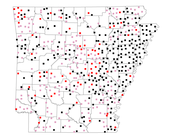
Total number of 2,500 hectare plots where this species is found: 506 ( 57.8% of plots )
| CATEGORY | Hectares, 1994 | % of Total, 1994 | Hectares, 1999 | % of Total, 1999 | Hectares, 2004 | % of Total, 2004 |
| Forest - Total (All Categories) | 569155.1 | 40.60 | 576706.8 | 45.58 | 579102.9 | 45.77 |
| Ozark-Ouachita Pine-Oak Forest | 137008.6 | 9.77 | 118419.0 | 9.36 | 116046.3 | 9.17 |
| Ozark-Ouachita Dry Oak Woodland and Forest | 24086.6 | 1.72 | 17086.9 | 1.35 | 16916.5 | 1.34 |
| Central Interior Highlands Glade and Barrens | 20994.9 | 1.50 | 16163.6 | 1.28 | 16168.2 | 1.28 |
| Mesic Hardwood Forest | 1092.4 | 0.08 | 962.6 | 0.08 | 953.7 | 0.08 |
| Dry-Mesic Oak Forest | 137460.7 | 9.81 | 108909.6 | 8.61 | 106373.9 | 8.41 |
| West Gulf Coastal Plain Pine-Hardwood Forest | 87679.1 | 6.25 | 75505.1 | 5.97 | 71299.9 | 5.64 |
| West Gulf Coastal Plain Small Stream Forest | 1285.7 | 0.09 | 631.9 | 0.05 | 630.7 | 0.05 |
| Lower Mississippi River Low Bottomland Forest | 46157.4 | 3.29 | 33940.4 | 2.68 | 34216.4 | 2.70 |
| Lower Mississippi River High Bottomland Forest | 104470.0 | 7.45 | 85081.2 | 6.72 | 83541.8 | 6.60 |
| Lower Mississippi River Bottomland Depression | 3216.0 | 0.23 | 2378.5 | 0.19 | 2340.5 | 0.18 |
| Lower Mississippi River Riparian Forest | 1729.8 | 0.12 | 499.7 | 0.04 | 579.4 | 0.05 |
| Sweetgum | 3973.9 | 0.28 | 3076.8 | 0.24 | 2979.8 | 0.24 |
| Forest - Unknown Category | 0.0 | 0.00 | 114051.5 | 9.01 | 127055.8 | 10.04 |
| Cropland | 490038.9 | 34.96 | 389473.1 | 30.78 | 381209.7 | 30.13 |
| Pastureland | 266600.7 | 19.02 | 218806.2 | 17.29 | 201675.3 | 15.94 |
| Herbaceous | 4143.5 | 0.30 | 12197.2 | 0.96 | 16148.8 | 1.28 |
| Bare/Barren | 2067.1 | 0.15 | 687.5 | 0.05 | 1694.9 | 0.13 |
| Urban | 7046.3 | 0.50 | 15785.0 | 1.25 | 37694.7 | 2.98 |
| Water | 44209.2 | 3.15 | 34990.2 | 2.77 | 31083.5 | 2.46 |
| Unknown (No Data) | 18638.0 | 1.33 | 16527.7 | 1.31 | 16563.8 | 1.31 |