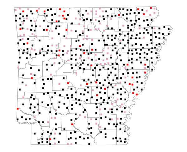
Species Report
House Sparrow

Total number of 2,500 hectare plots where this species is found: 580 ( 66.3% of plots )
| CATEGORY | Hectares, 1994 | % of Total, 1994 | Hectares, 1999 | % of Total, 1999 | Hectares, 2004 | % of Total, 2004 |
| Forest - Total (All Categories) | 735909.9 | 45.80 | 734646.9 | 50.65 | 732063.2 | 50.48 |
| Ozark-Ouachita Pine-Oak Forest | 174949.7 | 10.89 | 150995.2 | 10.41 | 147913.8 | 10.20 |
| Ozark-Ouachita Dry Oak Woodland and Forest | 40391.4 | 2.51 | 30296.8 | 2.09 | 29676.0 | 2.05 |
| Central Interior Highlands Glade and Barrens | 32698.6 | 2.03 | 26195.8 | 1.81 | 25833.8 | 1.78 |
| Mesic Hardwood Forest | 1513.6 | 0.09 | 1319.3 | 0.09 | 1308.1 | 0.09 |
| Dry-Mesic Oak Forest | 194845.7 | 12.13 | 156306.3 | 10.78 | 152332.5 | 10.50 |
| West Gulf Coastal Plain Pine-Hardwood Forest | 122248.3 | 7.61 | 106018.8 | 7.31 | 99668.0 | 6.87 |
| West Gulf Coastal Plain Small Stream Forest | 1135.1 | 0.07 | 612.3 | 0.04 | 599.8 | 0.04 |
| Lower Mississippi River Low Bottomland Forest | 41722.7 | 2.60 | 30465.2 | 2.10 | 30699.6 | 2.12 |
| Lower Mississippi River High Bottomland Forest | 115441.1 | 7.18 | 94828.2 | 6.54 | 92968.8 | 6.41 |
| Lower Mississippi River Bottomland Depression | 4234.1 | 0.26 | 3319.3 | 0.23 | 3257.0 | 0.22 |
| Lower Mississippi River Riparian Forest | 1744.6 | 0.11 | 523.6 | 0.04 | 607.7 | 0.04 |
| Sweetgum | 4985.1 | 0.31 | 3968.8 | 0.27 | 3845.6 | 0.27 |
| Forest - Unknown Category | 0.0 | 0.00 | 129797.4 | 8.95 | 143352.5 | 9.88 |
| Cropland | 468380.9 | 29.15 | 368851.9 | 25.43 | 360661.7 | 24.87 |
| Pastureland | 325518.9 | 20.26 | 264295.8 | 18.22 | 247750.0 | 17.08 |
| Herbaceous | 4045.4 | 0.25 | 12446.6 | 0.86 | 17117.9 | 1.18 |
| Bare/Barren | 1581.0 | 0.10 | 489.7 | 0.03 | 1591.0 | 0.11 |
| Urban | 9124.3 | 0.57 | 16474.2 | 1.14 | 42101.6 | 2.90 |
| Water | 45997.2 | 2.86 | 38748.1 | 2.67 | 34631.7 | 2.39 |
| Unknown (No Data) | 16299.1 | 1.01 | 14392.3 | 0.99 | 14428.3 | 0.99 |