Species Report
Horned Lark
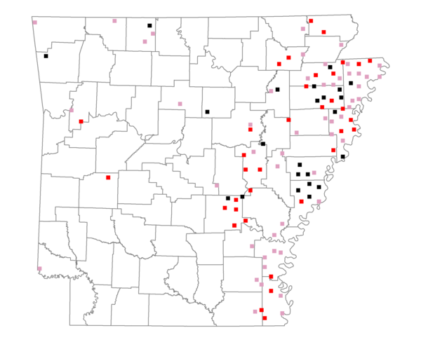
Total number of 2,500 hectare plots where this species is found: 109 ( 12.5% of plots )
| CATEGORY | Hectares, 1994 | % of Total, 1994 | Hectares, 1999 | % of Total, 1999 | Hectares, 2004 | % of Total, 2004 |
| Forest - Total (All Categories) | 51518.6 | 17.06 | 45289.6 | 16.62 | 51121.9 | 18.76 |
| Ozark-Ouachita Pine-Oak Forest | 4958.1 | 1.64 | 3920.0 | 1.44 | 3913.5 | 1.44 |
| Ozark-Ouachita Dry Oak Woodland and Forest | 2544.3 | 0.84 | 1483.9 | 0.54 | 1508.0 | 0.55 |
| Central Interior Highlands Glade and Barrens | 2846.3 | 0.94 | 2001.5 | 0.73 | 2026.2 | 0.74 |
| Mesic Hardwood Forest | 0.0 | 0.00 | 0.0 | 0.00 | 0.0 | 0.00 |
| Dry-Mesic Oak Forest | 10848.7 | 3.59 | 7123.7 | 2.61 | 6956.6 | 2.55 |
| West Gulf Coastal Plain Pine-Hardwood Forest | 31.1 | 0.01 | 26.7 | 0.01 | 26.6 | 0.01 |
| West Gulf Coastal Plain Small Stream Forest | 342.7 | 0.11 | 233.9 | 0.09 | 197.5 | 0.07 |
| Lower Mississippi River Low Bottomland Forest | 16486.1 | 5.46 | 11700.1 | 4.29 | 12216.7 | 4.48 |
| Lower Mississippi River High Bottomland Forest | 11855.0 | 3.93 | 8409.1 | 3.09 | 8434.7 | 3.09 |
| Lower Mississippi River Bottomland Depression | 481.1 | 0.16 | 243.5 | 0.09 | 251.2 | 0.09 |
| Lower Mississippi River Riparian Forest | 606.3 | 0.20 | 51.9 | 0.02 | 66.6 | 0.02 |
| Sweetgum | 518.9 | 0.17 | 406.5 | 0.15 | 420.7 | 0.15 |
| Forest - Unknown Category | 0.0 | 0.00 | 9688.7 | 3.56 | 15103.5 | 5.54 |
| Cropland | 220687.6 | 73.07 | 189365.8 | 69.48 | 182314.7 | 66.90 |
| Pastureland | 13849.7 | 4.59 | 20702.9 | 7.60 | 18788.6 | 6.89 |
| Herbaceous | 2048.8 | 0.68 | 2944.2 | 1.08 | 3262.7 | 1.20 |
| Bare/Barren | 517.3 | 0.17 | 1.9 | 0.00 | 520.8 | 0.19 |
| Urban | 1446.6 | 0.48 | 3103.6 | 1.14 | 6765.7 | 2.48 |
| Water | 8679.7 | 2.87 | 8317.9 | 3.05 | 6948.9 | 2.55 |
| Unknown (No Data) | 3262.9 | 1.08 | 2808.2 | 1.03 | 2810.7 | 1.03 |