Species Report
Field Sparrow
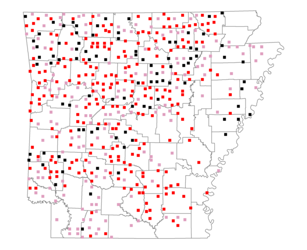
Total number of 2,500 hectare plots where this species is found: 503 ( 57.5% of plots )
| CATEGORY | Hectares, 1994 | % of Total, 1994 | Hectares, 1999 | % of Total, 1999 | Hectares, 2004 | % of Total, 2004 |
| Forest - Total (All Categories) | 824820.5 | 59.17 | 844306.0 | 67.11 | 835727.6 | 66.43 |
| Ozark-Ouachita Pine-Oak Forest | 271671.0 | 19.49 | 238514.1 | 18.96 | 234306.8 | 18.63 |
| Ozark-Ouachita Dry Oak Woodland and Forest | 50302.4 | 3.61 | 38390.9 | 3.05 | 37731.9 | 3.00 |
| Central Interior Highlands Glade and Barrens | 41401.9 | 2.97 | 33534.5 | 2.67 | 33108.9 | 2.63 |
| Mesic Hardwood Forest | 2138.6 | 0.15 | 1870.0 | 0.15 | 1862.7 | 0.15 |
| Dry-Mesic Oak Forest | 221291.3 | 15.88 | 183350.9 | 14.57 | 179417.6 | 14.26 |
| West Gulf Coastal Plain Pine-Hardwood Forest | 119136.6 | 8.55 | 103512.8 | 8.23 | 97557.4 | 7.75 |
| West Gulf Coastal Plain Small Stream Forest | 308.0 | 0.02 | 248.1 | 0.02 | 258.7 | 0.02 |
| Lower Mississippi River Low Bottomland Forest | 18518.1 | 1.33 | 14830.0 | 1.18 | 14589.4 | 1.16 |
| Lower Mississippi River High Bottomland Forest | 90527.2 | 6.49 | 75697.0 | 6.02 | 74502.6 | 5.92 |
| Lower Mississippi River Bottomland Depression | 3276.5 | 0.24 | 2859.5 | 0.23 | 2757.8 | 0.22 |
| Lower Mississippi River Riparian Forest | 480.7 | 0.03 | 299.2 | 0.02 | 334.6 | 0.03 |
| Sweetgum | 5768.3 | 0.41 | 4729.7 | 0.38 | 4526.1 | 0.36 |
| Forest - Unknown Category | 0.0 | 0.00 | 146469.2 | 11.64 | 154773.2 | 12.30 |
| Cropland | 153135.3 | 10.99 | 94025.7 | 7.47 | 93019.1 | 7.39 |
| Pastureland | 364714.3 | 26.16 | 267097.5 | 21.23 | 251975.2 | 20.03 |
| Herbaceous | 1319.1 | 0.09 | 8479.5 | 0.67 | 14879.5 | 1.18 |
| Bare/Barren | 408.7 | 0.03 | 315.2 | 0.03 | 648.0 | 0.05 |
| Urban | 5617.5 | 0.40 | 8411.5 | 0.67 | 27486.1 | 2.18 |
| Water | 33164.9 | 2.38 | 25840.4 | 2.05 | 24680.0 | 1.96 |
| Unknown (No Data) | 10732.9 | 0.77 | 9533.9 | 0.76 | 9594.1 | 0.76 |