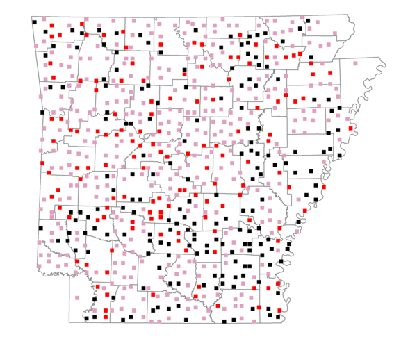
Species Report
Downy Woodpecker

Total number of 2,500 hectare plots where this species is found: 684 ( 78.2% of plots )
| CATEGORY | Hectares, 1994 | % of Total, 1994 | Hectares, 1999 | % of Total, 1999 | Hectares, 2004 | % of Total, 2004 |
| Forest - Total (All Categories) | 1067682.9 | 56.35 | 1080439.4 | 63.17 | 1067693.1 | 62.42 |
| Ozark-Ouachita Pine-Oak Forest | 299597.7 | 15.81 | 263049.4 | 15.38 | 258527.4 | 15.11 |
| Ozark-Ouachita Dry Oak Woodland and Forest | 45130.3 | 2.38 | 34597.8 | 2.02 | 34044.2 | 1.99 |
| Central Interior Highlands Glade and Barrens | 38109.1 | 2.01 | 31032.3 | 1.81 | 30627.8 | 1.79 |
| Mesic Hardwood Forest | 1905.9 | 0.10 | 1669.1 | 0.10 | 1668.1 | 0.10 |
| Dry-Mesic Oak Forest | 251431.7 | 13.27 | 208165.3 | 12.17 | 203630.9 | 11.91 |
| West Gulf Coastal Plain Pine-Hardwood Forest | 202678.5 | 10.70 | 175638.9 | 10.27 | 164308.7 | 9.61 |
| West Gulf Coastal Plain Small Stream Forest | 1296.1 | 0.07 | 666.3 | 0.04 | 711.1 | 0.04 |
| Lower Mississippi River Low Bottomland Forest | 47795.5 | 2.52 | 36878.1 | 2.16 | 36606.4 | 2.14 |
| Lower Mississippi River High Bottomland Forest | 163667.8 | 8.64 | 137774.8 | 8.06 | 135150.0 | 7.90 |
| Lower Mississippi River Bottomland Depression | 7853.9 | 0.41 | 6481.3 | 0.38 | 6278.4 | 0.37 |
| Lower Mississippi River Riparian Forest | 1602.6 | 0.08 | 538.8 | 0.03 | 588.1 | 0.03 |
| Sweetgum | 6613.9 | 0.35 | 5408.0 | 0.32 | 5236.7 | 0.31 |
| Forest - Unknown Category | 0.0 | 0.00 | 178539.4 | 10.44 | 190315.3 | 11.13 |
| Cropland | 345517.2 | 18.23 | 250062.9 | 14.62 | 246446.4 | 14.41 |
| Pastureland | 388699.1 | 20.51 | 281983.3 | 16.49 | 266517.0 | 15.58 |
| Herbaceous | 3188.1 | 0.17 | 16971.6 | 0.99 | 25707.7 | 1.50 |
| Bare/Barren | 1911.3 | 0.10 | 946.8 | 0.06 | 1728.7 | 0.10 |
| Urban | 8073.4 | 0.43 | 14859.3 | 0.87 | 40280.4 | 2.36 |
| Water | 58561.9 | 3.09 | 46263.2 | 2.70 | 43096.5 | 2.52 |
| Unknown (No Data) | 21262.7 | 1.12 | 18886.7 | 1.10 | 18943.5 | 1.11 |