Species Report
Bank Swallow
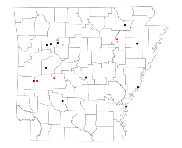
Total number of 2,500 hectare plots where this species is found: 25 ( 2.9% of plots )
| CATEGORY | Hectares, 1994 | % of Total, 1994 | Hectares, 1999 | % of Total, 1999 | Hectares, 2004 | % of Total, 2004 |
| Forest - Total (All Categories) | 36191.5 | 52.24 | 36983.7 | 59.19 | 37437.0 | 59.91 |
| Ozark-Ouachita Pine-Oak Forest | 17385.4 | 25.09 | 15316.5 | 24.51 | 15182.3 | 24.30 |
| Ozark-Ouachita Dry Oak Woodland and Forest | 1664.2 | 2.40 | 1389.5 | 2.22 | 1354.2 | 2.17 |
| Central Interior Highlands Glade and Barrens | 1484.8 | 2.14 | 1286.7 | 2.06 | 1283.0 | 2.05 |
| Mesic Hardwood Forest | 165.1 | 0.24 | 142.5 | 0.23 | 145.7 | 0.23 |
| Dry-Mesic Oak Forest | 6719.4 | 9.70 | 5578.2 | 8.93 | 5537.8 | 8.86 |
| West Gulf Coastal Plain Pine-Hardwood Forest | 396.6 | 0.57 | 290.7 | 0.47 | 287.5 | 0.46 |
| West Gulf Coastal Plain Small Stream Forest | 158.2 | 0.23 | 93.7 | 0.15 | 103.6 | 0.17 |
| Lower Mississippi River Low Bottomland Forest | 1409.0 | 2.03 | 1077.1 | 1.72 | 1096.4 | 1.75 |
| Lower Mississippi River High Bottomland Forest | 6157.9 | 8.89 | 5071.1 | 8.12 | 5033.3 | 8.05 |
| Lower Mississippi River Bottomland Depression | 108.6 | 0.16 | 73.8 | 0.12 | 80.9 | 0.13 |
| Lower Mississippi River Riparian Forest | 137.6 | 0.20 | 87.1 | 0.14 | 92.3 | 0.15 |
| Sweetgum | 404.7 | 0.58 | 346.7 | 0.55 | 338.1 | 0.54 |
| Forest - Unknown Category | 0.0 | 0.00 | 6230.0 | 9.97 | 6902.1 | 11.05 |
| Cropland | 16509.8 | 23.83 | 11329.5 | 18.13 | 11160.4 | 17.86 |
| Pastureland | 9709.4 | 14.01 | 7602.4 | 12.17 | 6998.9 | 11.20 |
| Herbaceous | 212.0 | 0.31 | 647.3 | 1.04 | 573.2 | 0.92 |
| Bare/Barren | 132.9 | 0.19 | 182.4 | 0.29 | 96.6 | 0.15 |
| Urban | 315.2 | 0.45 | 606.8 | 0.97 | 1282.7 | 2.05 |
| Water | 4009.6 | 5.79 | 3142.2 | 5.03 | 2945.5 | 4.71 |
| Unknown (No Data) | 2204.8 | 3.18 | 1992.4 | 3.19 | 1992.4 | 3.19 |