Species Report
American Kestrel
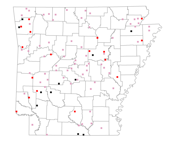
Total number of 2,500 hectare plots where this species is found: 95 ( 10.9% of plots )
| CATEGORY | Hectares, 1994 | % of Total, 1994 | Hectares, 1999 | % of Total, 1999 | Hectares, 2004 | % of Total, 2004 |
| Forest - Total (All Categories) | 134015.5 | 50.92 | 136042.7 | 57.28 | 135759.6 | 57.16 |
| Ozark-Ouachita Pine-Oak Forest | 49780.5 | 18.92 | 43178.8 | 18.18 | 42149.7 | 17.75 |
| Ozark-Ouachita Dry Oak Woodland and Forest | 6068.7 | 2.31 | 4567.4 | 1.92 | 4405.2 | 1.85 |
| Central Interior Highlands Glade and Barrens | 4482.0 | 1.70 | 3536.9 | 1.49 | 3482.4 | 1.47 |
| Mesic Hardwood Forest | 89.8 | 0.03 | 79.5 | 0.03 | 78.1 | 0.03 |
| Dry-Mesic Oak Forest | 32397.9 | 12.31 | 24694.2 | 10.40 | 23772.5 | 10.01 |
| West Gulf Coastal Plain Pine-Hardwood Forest | 16179.1 | 6.15 | 13769.9 | 5.80 | 12382.9 | 5.21 |
| West Gulf Coastal Plain Small Stream Forest | 0.0 | 0.00 | 0.0 | 0.00 | 0.0 | 0.00 |
| Lower Mississippi River Low Bottomland Forest | 6480.0 | 2.46 | 5085.3 | 2.14 | 5068.4 | 2.13 |
| Lower Mississippi River High Bottomland Forest | 16332.5 | 6.21 | 13279.5 | 5.59 | 13088.3 | 5.51 |
| Lower Mississippi River Bottomland Depression | 1156.4 | 0.44 | 983.0 | 0.41 | 928.2 | 0.39 |
| Lower Mississippi River Riparian Forest | 82.1 | 0.03 | 34.6 | 0.01 | 37.9 | 0.02 |
| Sweetgum | 966.4 | 0.37 | 801.1 | 0.34 | 797.9 | 0.34 |
| Forest - Unknown Category | 0.0 | 0.00 | 26032.5 | 10.96 | 29568.3 | 12.45 |
| Cropland | 52625.3 | 20.00 | 36207.5 | 15.25 | 34816.7 | 14.66 |
| Pastureland | 64914.3 | 24.67 | 50612.0 | 21.31 | 45665.3 | 19.23 |
| Herbaceous | 948.9 | 0.36 | 2416.8 | 1.02 | 3688.0 | 1.55 |
| Bare/Barren | 9.4 | 0.00 | 160.8 | 0.07 | 415.2 | 0.17 |
| Urban | 2356.2 | 0.90 | 5042.4 | 2.12 | 11017.0 | 4.64 |
| Water | 7229.3 | 2.75 | 6045.1 | 2.55 | 5165.9 | 2.18 |
| Unknown (No Data) | 1071.9 | 0.41 | 968.0 | 0.41 | 967.5 | 0.41 |