Species Report
Loggerhead Shrike
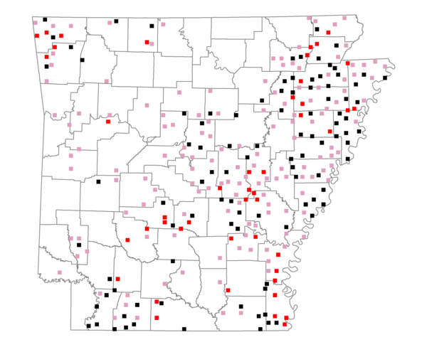
Total number of 2,500 hectare plots where this species is found: 288 ( 32.9% of plots )
| CATEGORY | Hectares, 1994 | % of Total, 1994 | Hectares, 1999 | % of Total, 1999 | Hectares, 2004 | % of Total, 2004 |
| Forest - Total (All Categories) | 260027.1 | 32.59 | 255063.2 | 35.42 | 257578.5 | 35.77 |
| Ozark-Ouachita Pine-Oak Forest | 41976.8 | 5.26 | 35706.8 | 4.96 | 34819.3 | 4.84 |
| Ozark-Ouachita Dry Oak Woodland and Forest | 8208.6 | 1.03 | 5435.6 | 0.75 | 5376.7 | 0.75 |
| Central Interior Highlands Glade and Barrens | 5894.8 | 0.74 | 3890.3 | 0.54 | 3976.2 | 0.55 |
| Mesic Hardwood Forest | 247.1 | 0.03 | 212.6 | 0.03 | 216.6 | 0.03 |
| Dry-Mesic Oak Forest | 54054.2 | 6.77 | 41196.8 | 5.72 | 40357.4 | 5.61 |
| West Gulf Coastal Plain Pine-Hardwood Forest | 50803.2 | 6.37 | 43674.7 | 6.07 | 41216.9 | 5.72 |
| West Gulf Coastal Plain Small Stream Forest | 1034.2 | 0.13 | 478.4 | 0.07 | 462.6 | 0.06 |
| Lower Mississippi River Low Bottomland Forest | 28148.2 | 3.53 | 19811.9 | 2.75 | 20297.6 | 2.82 |
| Lower Mississippi River High Bottomland Forest | 64728.5 | 8.11 | 52409.9 | 7.28 | 51481.3 | 7.15 |
| Lower Mississippi River Bottomland Depression | 1827.7 | 0.23 | 1360.8 | 0.19 | 1354.9 | 0.19 |
| Lower Mississippi River Riparian Forest | 1117.4 | 0.14 | 218.3 | 0.03 | 247.3 | 0.03 |
| Sweetgum | 1986.2 | 0.25 | 1510.2 | 0.21 | 1483.8 | 0.21 |
| Forest - Unknown Category | 0.0 | 0.00 | 49156.9 | 6.83 | 56288.0 | 7.82 |
| Cropland | 380502.4 | 47.69 | 317544.7 | 44.10 | 310403.4 | 43.11 |
| Pastureland | 117540.5 | 14.73 | 103006.6 | 14.31 | 96410.0 | 13.39 |
| Herbaceous | 3056.9 | 0.38 | 6782.2 | 0.94 | 8975.7 | 1.25 |
| Bare/Barren | 1674.7 | 0.21 | 295.1 | 0.04 | 1158.0 | 0.16 |
| Urban | 4027.0 | 0.50 | 10751.2 | 1.49 | 22061.2 | 3.06 |
| Water | 24709.7 | 3.10 | 21012.3 | 2.92 | 17859.8 | 2.48 |
| Unknown (No Data) | 6354.1 | 0.80 | 5564.7 | 0.77 | 5573.3 | 0.77 |