Species Report
Eastern Bluebird
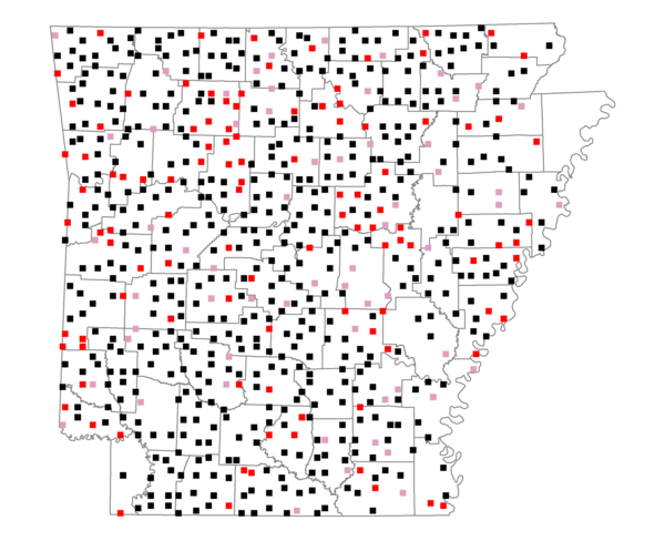
Total number of 2,500 hectare plots where this species is found: 680 ( 77.7% of plots )
| CATEGORY | Hectares, 1994 | % of Total, 1994 | Hectares, 1999 | % of Total, 1999 | Hectares, 2004 | % of Total, 2004 |
| Forest - Total (All Categories) | 1080607.7 | 57.36 | 1094354.5 | 64.35 | 1080469.9 | 63.54 |
| Ozark-Ouachita Pine-Oak Forest | 311722.6 | 16.55 | 272794.9 | 16.04 | 267707.9 | 15.74 |
| Ozark-Ouachita Dry Oak Woodland and Forest | 53371.5 | 2.83 | 40700.5 | 2.39 | 40049.8 | 2.36 |
| Central Interior Highlands Glade and Barrens | 47450.2 | 2.52 | 38357.8 | 2.26 | 37985.8 | 2.23 |
| Mesic Hardwood Forest | 2299.3 | 0.12 | 2015.6 | 0.12 | 2002.8 | 0.12 |
| Dry-Mesic Oak Forest | 265296.6 | 14.08 | 219122.8 | 12.89 | 214141.8 | 12.59 |
| West Gulf Coastal Plain Pine-Hardwood Forest | 197888.9 | 10.50 | 171667.2 | 10.09 | 160906.1 | 9.46 |
| West Gulf Coastal Plain Small Stream Forest | 944.0 | 0.05 | 621.0 | 0.04 | 597.9 | 0.04 |
| Lower Mississippi River Low Bottomland Forest | 36606.8 | 1.94 | 27600.2 | 1.62 | 27262.0 | 1.60 |
| Lower Mississippi River High Bottomland Forest | 150913.6 | 8.01 | 126863.5 | 7.46 | 124392.1 | 7.31 |
| Lower Mississippi River Bottomland Depression | 5916.5 | 0.31 | 4926.0 | 0.29 | 4704.5 | 0.28 |
| Lower Mississippi River Riparian Forest | 1317.1 | 0.07 | 516.5 | 0.03 | 572.0 | 0.03 |
| Sweetgum | 6880.6 | 0.37 | 5598.6 | 0.33 | 5408.7 | 0.32 |
| Forest - Unknown Category | 0.0 | 0.00 | 183570.1 | 10.79 | 194738.3 | 11.45 |
| Cropland | 302625.1 | 16.06 | 210624.4 | 12.39 | 207367.8 | 12.19 |
| Pastureland | 422668.9 | 22.44 | 310000.4 | 18.23 | 293360.8 | 17.25 |
| Herbaceous | 2483.4 | 0.13 | 15740.2 | 0.93 | 24624.5 | 1.45 |
| Bare/Barren | 835.1 | 0.04 | 616.5 | 0.04 | 1436.8 | 0.08 |
| Urban | 8152.6 | 0.43 | 14439.0 | 0.85 | 40970.2 | 2.41 |
| Water | 50605.5 | 2.69 | 40700.0 | 2.39 | 38183.2 | 2.25 |
| Unknown (No Data) | 15877.5 | 0.84 | 14073.9 | 0.83 | 14135.6 | 0.83 |